Track network data, but the right way! End-to-End digital planning begins with geo data preparation in PlanPro GEO Planner v1.0
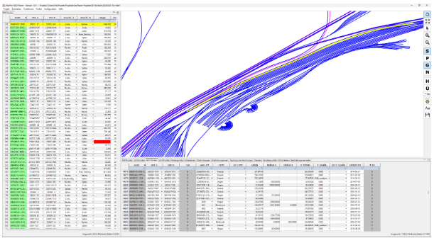
For geodata preparation as one of the first steps in the digital planning process, the DSD project "Consistent Digital Data Management in CCS Planning" (D3iP) has published version 1.0 of the PlanPro-GEO-Planer tool. Track network data in GNDedit or ASCIBAHN format in – track network data in PlanPro format out: this is how inputs with the PlanPro GEO Planner can be summarized. On closer inspection, however, the supposedly simple format conversions presents a number of challenges that the PlanPro GEO Planner was tailor-made to overcome. Merging GEO nodes, breaking TOP edges and the topological localization of point objects are just some of the functions that the tool offer its users.
In the rail industry, almost all planning of technical track equipment is based on track network data. In the area of control and safety technology, DB InfraGO has opted for PlanPro, an XML-based exchange format that can transport the planning parameters of all sub-trades and is based on a two-level node-edge model to describe both the geometry and the topology of a rail infrastructure. Since DB’s geodata management itself cannot provide track network data in PlanPro format and the manufacturers of the specialist planning tools did not (initially) see themselves as responsible for a conversion, DB InfraGO decided to have a corresponding tool developed by SIGNON Deutschland GmbH: the PlanPro GEO Planner was born.
2300 agile development tickets later, the PlanPro GEO Planner version 1.0 is now available to interested users. The current range of functions includes:
- Import from:
- GNDedit (existing track network data form AVANI)
- ASCIBAHN (alignment)
- PlanPro (v.1.9, v1.0)
- Visualization in map and table display
- Function automation
- Merge GEO nodes
- Break GEO/TOP edges
- Connection determination a length calculation TOP edges
- Topological localization of elevation points and superelevation
- Creation, attribute editing and deletion for all object types
- Export PlanPro (1.9, 1.10) + explanatory report
Since the start of development of PlanPro GEO Planner in 2019, the range of LST planning tools has expanded and with it their functional scope. There are now more tools that can process geodata. But do different tools produce the same processing results with the same input (rail network) data? GEO Planner, with its more than 90 checking rules, can provide excellent support in answering this question. Many technical aspects whose compliance cannot be validated by the XML schema of the PlanPro data model are ensured by "PlaZ-GEO" (PlaZ = plausibility and admissibility check; based on PlaZ-LST in the PlanPro toolbox) from GEO Planner.
In addition to geodata preparation and quality assurance, the PlanPro GEO planner also offers the option of locating LST objects of the existing track infrastructure. A database-based exchange format (SQLite) has been created for this purpose, which the PlanPro GEO Planner can also process as part of the PlanPro export. Such an object database (ODB) contains information on physical objects in the nearby track environment, which are typically captured by rail-related inspection. The ODB2PlanPro converter component generates corresponding PlanPro objects from the information and determines topological locations from the geo-coordinates - a one-dimensional position specification along a topological edge.

The PlanPro GEO Planner can be downloaded from the PlanPro delivery Portal. The following access data must be entered:
- User name: vsi\PlanPro1100
- Password: SP_Ppro#2-1$
A training document and a user guide are also available under the link.
If you have any questions or suggestions regarding PlanPro GEO Planner, please contact
