Digital Maps for Railway Operations: Gordon Isaac on the Challenges and Benefits of Digital Maps in Automated Rail Operations
Digital maps provide a highly precise digital representation of railway infrastructure and support reliable obstacle detection as well as the precise train localisation required for it. They form a fundamental basis for digitalised railway operations but are also beneficial for a wide range of additional applications within the railway system. We spoke with Gordon Isaac about the significance of this technology within the collaborative project AutomatedTrain and beyond. Within AutomatedTrain, he serves as sub-project manager responsible for the digital map.
Gordon, in simple terms, what should one understand by the digital map in the AutomatedTrain collaboration project?
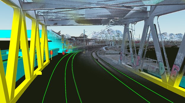
Our digital map is a precise digital representation of railway infrastructure. It contains exact location information about objects such as tracks, signals, overhead line masts or platforms. It also describes the three-dimensional dimensions of these objects, meaning their exact size and structure. Furthermore, the digital map represents the topology of the railway line, meaning that it also shows the relationships between different objects. For example, it becomes clear which routing options exist between different tracks or which objects are relevant for a specific track section.
Deutsche Bahn has launched several projects related to (digital) maps, such as InfraMaps or the Digital Command system (Digitaler Befehl), which create significant added value in day-to-day operations. The distinctive feature of the digital map created within the AutomatedTrain project results from its use case: fully automated train operation. In order to use a digital map for fully automated driving, significantly more detail and a much higher level of precision are required. One part of the AutomatedTrain project was therefore to work together with project partners to determine which contents a digital map must include to support automated train operation in this particular use case.
What role does the digital map play in the AutomatedTrain research and development project? And what are the maps used for?
The digital map acts as an important reference for on-board train systems. These systems are informed by the digital map about the expected state of the environment along the route. For example: “A building should be located here and a mast there.” The digital map is therefore used in a similar way to a sensor as an input source for route information and is then compared with the data recorded during train operation. This allows deviations between the expected and the actual state to be identified, which then serve as the basis for operational decisions.
One important field of application for digital maps is obstacle detection during fully automated train operation. Because trains have long braking distances, it is crucial to detect obstacles at a considerable distance. It is therefore essential to know the exact route of the train in order to determine whether an obstacle is located on or very close to the track. Furthermore, it is important to know all objects located along the route in order to distinguish between known and unknown objects. Legitimate objects can often be located very close to the track, such as signs or platforms. These should not be interpreted as obstacles and must therefore not trigger unnecessary braking.
The map is also used for train localisation. Knowledge of the exact track alignment and additional attributes such as track cant, track gradient and curve radii allows the expected position and orientation of the train to be determined more precisely. Infrastructure objects with known positions can also serve as landmarks that help calculate the exact position of the train. This is particularly relevant at platforms, for example, where trains must stop precisely at a predefined location. The digital map therefore serves as an important input source for safety-critical train systems such as obstacle detection and localisation. For this reason, high safety requirements apply to the digital map in terms of accuracy and completeness.
Which digital maps were produced within the AutomatedTrain project, and what were the key learnings?
During the course of the project, digital maps were created for all relevant test routes. These include routes in Berlin, Hennigsdorf and Wegberg-Wildenrath, as well as the main testing routes in Stuttgart – specifically the two S-Bahn lines between Bad Cannstatt and Kirchheim unter Teck and between Zuffenhausen and Böblingen – including the stabling facility in Esslingen. Part of the AutomatedTrain results will be presented in the Stuttgart region in June 2026.
It is worth emphasising that within the AutomatedTrain project we examined the entire process chain for creating and providing a digital map in a holistic manner. This provided numerous insights and advances. For example, concrete requirements for the digital map were defined for the first time, including specifications regarding relevant objects and required accuracy. The surveying and object recognition carried out on the collected data showed that meeting these demanding requirements requires complex data processing and a very high level of detail.
Whether the requirements truly need to be this precise will become clear during practical testing. In addition, we succeeded for the first time in developing an interface that defines the data exchange format between the map and the train. This interface will also be validated further during real train operation as the project progresses.
What challenges does automated railway operation pose for the digital map?
Automated railway operation introduces a use case that places particularly high demands on the digital map in terms of accuracy, completeness, correctness and verifiability of the data. Since maps meeting these requirements do not yet exist in the railway sector, new maps must first be surveyed. At the same time, a process for creating these maps must be developed, and evidence must be provided that this process meets the new and demanding requirements.
For this reason, the digital map was integrated into the requirements process from the outset within the AutomatedTrain project. The system requirements of all systems that will use the digital map were described in detail, not only in terms of content but also with regard to safety requirements. Based on a comprehensive catalogue of requirements, a process can be developed that demonstrably meets the high standards for accuracy and completeness. Within the project, this process was initially set up in a prototype form in order to gain insights into which steps are necessary to establish the basis for later certification and verification. On this basis, a prototype process chain for producing the maps as a software product was implemented.
At the core of this process are repeated validation steps that ensure no deviations in accuracy or completeness occur at any stage. The process was analysed using a Failure Mode and Effects Analysis (FMEA) to identify potential procedural weaknesses. For each potential error source, validation measures were introduced in order to mitigate the risk. For example, to ensure positional accuracy in the surveying process, independently measured datasets produced using different methods are used for validation. Continuous comparison between raw data and the final product, together with the integration of secondary data sources, ensures the completeness of the digital map.
The process development within the project has already demonstrated that a thorough analysis of requirements is essential in order to verify the level of accuracy that is actually necessary. Because several process steps are required in the creation of the digital map, potential sources of error accumulate. Keeping the discrepancy between the cumulative error of the individual steps and the defined maximum permissible error as small as possible will remain a challenging task.


The AutomatedTrain project ends in September 2026. Where else will digital maps be used?
The data interface developed within the project – which describes both the content-related and qualitative requirements for map information – represents a key outcome of the project. The developed formats and processes will be made available for manufacturer-independent and interoperable use within European standardisation efforts, thereby supporting the digitalisation of railway operations across Europe. The digital map has now become part of European standardisation activities. It is being specified and standardised within the framework of the European initiative ERJU. This will enable all European railway operators in the future to access compatible infrastructure data.
Digital maps form an important foundation both for the automation and for the digitalisation of rail transport. However, they also offer significant advantages for the construction, modernisation and maintenance of railway infrastructure, for example through digital planning processes or faster approval procedures.
Digital maps have also proven to be an important data source for creating digital twins that are used to simulate scenarios for automated train operation. Using the map, a photorealistic representation of the railway system can be created. This allows rare disruption scenarios – such as a piece of luggage lying on the tracks – to be simulated realistically and in many different configurations. These scenarios can then be used to test and evaluate sensors as well as obstacle detection algorithms and systems under realistic conditions and at lower cost before more complex field tests begin.

Following the successful completion of the project, the industrial partners will be able to immediately begin their series development phases based on the results achieved. Digitale Schiene Deutschland has therefore provided important momentum for the sector and laid the groundwork for corresponding systems to potentially be ordered by railway operators from industry in the near future.
AutomatedTrain is funded by the Federal Republic of Germany and the European Union. Funding is provided by the Federal Ministry for Economic Affairs and Energy on the basis of a decision by the German Bundestag, as well as by the European Union.