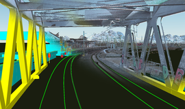
Digital Register – The „Single Source of Truth“ of infrastructure data for fully automated driving
Almost all key functionalities of the digital railway operations require highly accurate, up-to-date, and digitally available infrastructure data. To reach this goal, the DB Netz AG is intensively working on a so-called "Digital Register" as part of the sector initiative Digitale Schiene Deutschland as a uniform data basis for the systems of the digital rail operations.
Numerous pilot tests of Digitale Schiene Deutschland, conducted over the last four years, illustrate that there is a need for highly accurate, up-to-date, and digitally available infrastructure data: Sensor-based perception systems, that take over the role of track monitoring in fully automated driving, require knowledge about objects along the track to easily distinguish between dangerous and non-dangerous situations. Future localization systems need high-resolution digital maps as well as information about the exact, three-dimensional course of the track (3D track axes) to be able to perform explicit position determination. AI-based capacity and traffic management systems require up-to-date topology data to be able to digitally plan and control the traffic. For the training of AI functions in simulation environments or digital twins, real infrastructure data is needed as input in order to create realistic, virtual environments to be able to train, for example, the detection of obstacles and the initiation of an appropriate reaction during a fully automated journey.
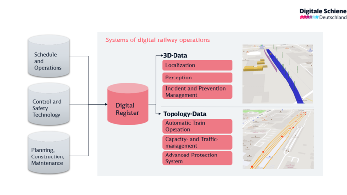
A homogeneous data basis and a central data source for infrastructure data is therefore essential for new systems of digital railway operation. The Digital Register keeps this data centrally available and updates and preprocess it. In this process, the Digital Register uses existing infrastructure data from various sources in different areas, such as "Timetable and Operations", "Control and Safety Technology" or "Planning, Construction and Maintenance". These data sets are aggregated, consolidated, and enriched with new, additional data sets that are necessary for fully automated driving. In addition, the Digital Register provides interfaces for a variety of key functionalities required for the digitization and automation of railway operations and thus acts as a "data hub" (cf. Figure 1).
Contents of the Digital Register
The data of the Digital Register can be roughly divided into 3D data and topology data. The 3D data describe highly precise localized objects such as 3D track axes, platforms, catenary poles, signs, boards, signals etc... This data is stored as simplified 3D objects and described more in detail by various attributes.
The topology data describes, at a high level, the logical connections of track elements, e.g., of switches or track terminations in the form of a so-called "node-edge model". This information is then described in more detail with data of relevant infrastructure elements, e.g., level crossings or tunnels and operational infrastructure data, e.g., speed profiles or gradients.
Creating the 3D data from highly accurate LiDAR point clouds
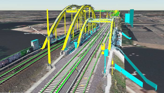
By "scanning" the relevant objects in three-dimensional space, high-precision Lidar point clouds are created. Lidar technology mounted on measuring vehicles are essentially lasers that scan the surroundings and based on reflection create a 3-dimensional representation of the environment. Subsequently objects are detected and then classified and precisely located. To do this, they are superimposed on the point cloud and simplified. This creates the overlay of 3D objects and point clouds shown in figure 2. Relevant objects are "labelled", which means they are identified and marked. These labelled objects of the point cloud move into the Digital Register. The collection of the 3D objects and thus the creation of a comprehensive data basis is currently primarily performed by manual labelling tasks.
The collected 3D objects serve as the basis for the creation of a high-resolution digital map "High Definition (HD) Map" with different map layers. Using these layers, partial areas (i.e., "tracks only", "platforms only") can be retrieved in addition to the entire map information. The HD-Map, a term originally used from the automotive sector, is focused on automated driving, the support of driving assistance systems and the localization of vehicles. For these purposes, in contrast to conventional navigation maps, the HD Map represents reality in a significantly higher level of detail with accuracies in the range of cm.
Sample application in the project Sensors4Rail (S4R): The Digital Register – represented by a high-resolution digital map – supporting the automatic train operation.
In Sensors4Rail project a Hamburg S-Bahn train was equipped with an extensive sensor setup (including camera, radar, Lidar, Global Navigation Satellite System (GNSS), Inertial Measurement Unit (IMU)) for the first time. It tested sensor-based perception systems (e.g., obstacle detection), which can take over the route monitoring and localization of the train during driverless driving of the highest automation level ATO GoA4 (Automatic Train Operation with Grade of Automation 4).
Several use cases were tested during the project for which the HD map represents an important input. In the project, the precise localization of the train's front position is calculated from a combination of different signal sources (GNSS, IMU, path pulse generator), recognized landmarks (with radar and Lidar) and a highly accurate 3D track axis from the HD map.
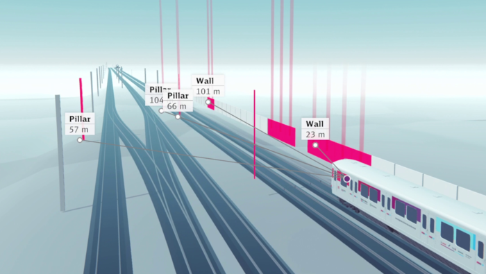
In addition to landmark detection (see fig. 3) and train localization, the functions of passenger detection, train detection, track detection and track clearance detection were also implemented with the support of HD-Map. To provide sufficiently up-to-date and accurate map data, more than 120 km of the Hamburg S-Bahn network were recorded in the project and "scanned" and "labelled" using the procedure described above.
Sample application in the project „Digitaler Knoten Stuttgart“ (DKS): The Digital Register as a source for infrastructure data for highly automated driving
In the pilot project Digitaler Knoten Stuttgart (DKS), based on the track equipment ETCS Level 2 without signals and the associated vehicle equipment, for the very first time in Germany, highly automated driving ATO GoA2 (Automatic Train Operation with Grade of Automation 2) is being implemented in passenger operation in a metropolitan region. The trains start, accelerate, brake and stop independently. The driver only monitors the route and intervenes only in the event of disturbances.
The vehicles are being equipped for ATO GoA2 as part of an innovation cooperation between industry, the state and DB Regio, whereas the trackside implementation is taking place in the Automated Rail@DKS project. In this project the first expansion stage of the Digital Register ("Basic-DR"), the basic functionality of the capacity and traffic management system ("CTMS-Translator") as well as the trackside ATO functionality (ATO-Tracksite) will be implemented for the Stuttgart S-Bahn and other regional services. Figure 4 shows the on-board and trackside equipment of the DKS.
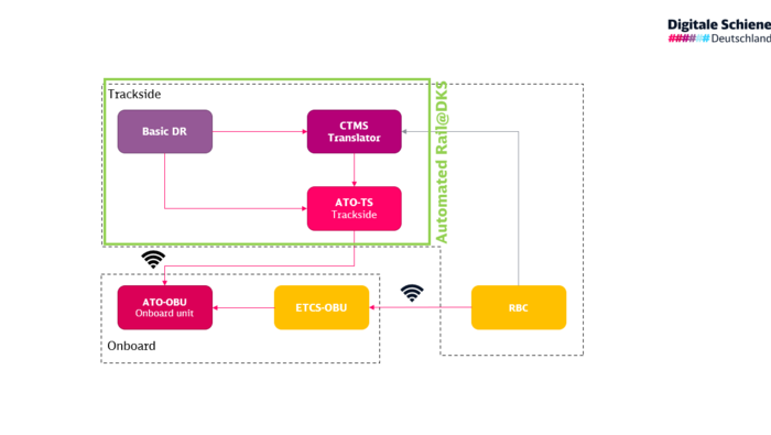
For the implementation of ATO GoA2, high quality operational infrastructure data is required, which must comply with the European standard (ATO over ETCS specification). To generate this data, to keep it complete and correct and to make it available to the ATO system in real time on request is the responsibility of the Digital Register, in case of Stuttgart represented by the system Basic-DR (see figure 4).
As a central infrastructure data management system for highly automated driving, the Basic-DR is an essential component for the implementation of highly automated driving in the railway system of the future. Technologically, the development of the Basic-DR as a cloud solution is already intended to prepare for an upcoming GoA2 area rollout. In addition to this overarching aspect, the cloud solution offers the advantage that the complete data management of the Basic-DR can be centralized and independent of any region (in this case Stuttgart).
Need for standardization and interoperability
The infrastructure data provided by the Digital Register for future automated railway operation in the levels GoA2 to GoA4 must be made equally available to all railway undertakings. For this reason, it is necessary to standardize the underlying data model and the interfaces of the system. Furthermore, the standardization of infrastructure data and interfaces shall promote the interoperability of rail transport within Europe. Thus, the Digital Register is also a central component of the so-called "Innovation Pillar" of Europe's Rail Joint Undertaking funded project "R2DATO" (Rail to Digital automated up to Autonomous Train Operation), which is part of the EU research program "Horizon Europe" and aims to create the basis for pioneering future technologies for the rail sector.
Future development of the Digital Register
With the implementation of the pilot project Digital Node Stuttgart, the Digital Register will go into operation for the first time. The technological foundations developed in this project will also be used for a later GoA2 area rollout - the rollout of highly automated driving throughout the entire route network in Germany. For 3D data and driverless railway operation in the GoA4 automation level, the task in the upcoming years will be to further validate the requirements for the data which the HD map needs to provide in research projects close to series production. The process of data acquisition, storage, and provisioning, as well as the data evaluation and data use will play an important role. This process has already been considered theoretically in the SafeRailMap project. The task now is to develop this further in close cooperation with the Bestandsdatenmanagement of DB Netz and to transfer it into reality. New methods and data sources (such as Building Information Modelling (BIM) objects) should simplify and improve the existing processes for labelling and validating 3D data in the future.